Geocentric Coordinate System
The geocentric coordinate system is a 3-dimensional Cartesian grid with the origin at the center of the earth. It has three axes (x, y, and z) and has the units of meters. Each of the axes is defined by a vector that starts from the center of the earth and intersects a point on the surface.
Modeler supports three geocentric coordinate systems:
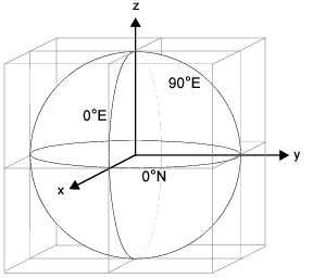
- right-sphere – The earth is modeled as a sphere, on which the x-axis intersects the surface at 0°N 0°E, the y-axis at 0°N 90°E, and the z-axis at 90°N.
- left-sphere – The earth is modeled as a sphere, on which the x-axis intersects the surface at 0°N 90°E, the y-axis at 0°N 0°E, and the z-axis at 90°N (x and y are reversed from the right-sphere system).
- ellipsoid – The earth is modeled as an ellipsoid, using the right-sphere coordinate axes.
The ellipsoid model is based on WGS-84 (World Geodetic System 1984). The equatorial radius is 6378137 meters and the polar radius is 6356752.3142 meters. The spherical models also use the WGS-84 equatorial radius.
The “geocentric_model” preference specifies the coordinate system being used.
Figure 190: Right-Sphere Geocentric Coordinate System
The Simulation Kernel computes the geocentric position coordinates for site objects only. The Kernel Procedure op_ima_obj_pos_get() returns the geocentric (as well as global) position coordinates of a site at the moment in the simulation when the procedure is invoked.
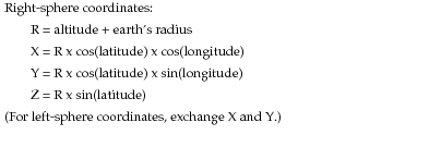
When the Simulation Kernel requires the geocentric position coordinates of a site, it computes them from the site’s global position coordinates using the following formulas:
Figure 191: Formulas for Conversion of Global Position Coordinates to Geocentric
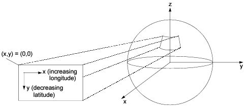
The x and y axes within the coordinate system of a subnetwork do not correspond to the x and y axes used in the geocentric coordinate system. For example, as the following diagram shows, a change in the y coordinate within the subnetwork possibly entails changes in all three geocentric position coordinates.
Figure 192: Relationship Between Subnetwork-Relative and Geocentric Coordinate Systems