Coloring Terrain Based on Elevation
You can color the terrain based on elevation. If you have a raster map, the color is superimposed on the image.
Procedure 53: Enabling or Disabling Coloring of Terrain by Elevation
-
Choose Settings > Terrain. The Terrain Settings dialog box opens.
-
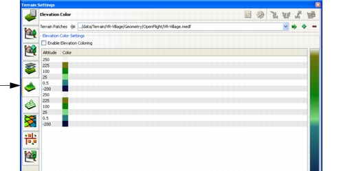
Select the Elevation Color Settings page (Figure 80).
Figure 80: Elevation Color Settings page
-
In the Terrain Patches list, select the terrain patch for which you want to enable elevation coloring.
-
Select or clear the Enable Elevation Coloring checkbox.
Configuring Elevation Color Settings
You can specify the color applied to terrain at a given altitude. You can add altitude points and remove them.
Inserting an Altitude Point
Procedure 54: Inserting an Altitude Point
- Choose Settings > Terrain. The Terrain Settings dialog box opens.
- Select the Elevation Color page (Figure 80).
- In the Terrain Patches list, select the terrain patch for which you want to insert an altitude point.
- Select an altitude point in the list that is above or below the altitude point you want to add.
- Click Insert Point. A new point is added with the same altitude as the one you selected.
- Double-click the new altitude point to make it editable.
- Set the altitude point to the altitude that you want.
- Click away from the altitude point to set it.
Deleting an Altitude Point
Procedure 55: Deleting an Altitude Point
- Choose Settings > Terrain. The Terrain Settings dialog box opens.
- Select the Elevation Color page (Figure 80).
- In the Terrain Patches list, select the terrain patch for which you want to delete an altitude point.
- Select the altitude point that you want to delete.
- Click Delete Point.
Changing the Color of an Altitude Point
Procedure 56: Changing the Color of an Altitude Point
- Choose Settings > Terrain. The Terrain Settings dialog box opens.
- Select the Elevation Color page (Figure 80).
- In the Terrain Patches list, select the terrain patch for which you want to change the color of an altitude point.
- Double-click the color swatch for the altitude point whose color you want to change. A color chooser dialog box opens.
- Select or specify a new color.
- Click OK.