Getting Started
The Terrain Modeling Module (TMM) enables you to enhance the accuracy of simulations by taking into account signal loss due to terrain effects.
TMM can use both physical features (such as mountains and the curvature of the earth) and environmental factors (such as ground conductivity and surface refractivity) as inputs to calculate signal loss. You can specify the propagation model and parameters used to perform signal-loss calculations.
Note: Because TMM requires both Riverbed Modeler and the Wireless functionality, this manual assumes you are familiar with how to use these products. It also assumes you are familiar with the operating system on which you are running the Riverbed software. Finally, you should have a general understanding of wireless networks and how terrain affects radio signals.
TMM includes several propagation models suitable for general, urban, and cellular simulations (see “Available Propagation Models” on page 16 for descriptions). The TIREM propagation model is available as optional functionality. In addition, you can create custom propagation models to meet special requirements, as described in “Creating Your Own Propagation Model” on page 37.
In the propagation models included with TMM, model parameters can be varied individually or as a group. If no value is assigned to a particular parameter, a default is used.
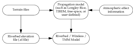
For physical features such as mountainous terrain, Riverbed uses terrain data from terrain data files. (See Table 1 for supported formats.) This data is applied to the propagation model along with any environmental factors defined, and path loss is calculated. In addition, terrain data can be imported and reformatted as an elevation map file for use as a network background image. The architecture of a TMM model and its inputs are shown in the following figure.
Figure 1: TMM Model Architecture