Vector-Based Trajectories
A vector-based trajectory consists of a direction and a velocity that can be changed at run time. You specify that a site will use a vector-based trajectory by setting the site’s trajectory attribute to VECTOR.
Vector-based trajectories rely on a great circle around the earth—specified by the bearing, ground speed, and ascent rate attributes—to define a site’s path. This circular path is centered at the center of the earth and passes through a specific point, usually the mobile or satellite site that is following the path. During simulation, the site’s latitude and longitude follow the circular trajectory. Contrary to statically defined trajectories, there is no time limit and the site’s position changes as long as ground speed and ascent rate are not zero.
For example, the following diagram shows a possible trajectory based on the “great circle” around the earth (shown as heavy red lines). The site’s latitude and longitude would be at the origin at the beginning of a simulation; the bearing, ground speed, and ascent rate attributes determine its path as the simulation progresses. Latitude/longitude coordinates follow the “great circle” path based on the ground speed of the site and the altitude varies based on the ascent rate.
Figure 13: Path of a Site on a Great Circle Route
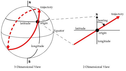
Note that the bearing is used only to determine which of the great circles passing through the origin will be used by the trajectory. The compass heading of an object following that trajectory (as given by the object’s yaw attribute) typically will change at each point along the trajectory.
Typically, a vector trajectory does not change during simulation. However, in Riverbed Modeler the path of a site can change during simulation if the bearing of the site is changed. In this case, the current latitude/longitude coordinates of the site become the new origin and a new “great circle” route is recomputed based on the new bearing and origin.