Managing Satellites
These procedures let you define a new satellite for viewing in the Orbit Viewer and update orbit information for a satellite.
Adding a Satellite
Use this procedure to define a satellite that can be animated in the Orbit Viewer.
Procedure 21: Adding a Satellite
-
Choose Objects > Create Satellite, or click the Add Satellite button in the toolbar.
Figure 49: Add Satellite Toolbar Button

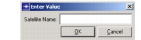
op_vuorb opens a text entry area for naming the satellite.
Figure 50: Dialog Box for Naming a Satellite
-
Enter a name and press OK.
The satellite is added to the data table.
Figure 51: Satellite Data Table

-
Enter values in the data table to assign an orbit and other attributes to the satellite. The attributes are described in Table 15.
The following table lists satellite attributes.
Table 15: Satellite Attributes
| Attribute | Description |
|---|---|
| Name | The name of the satellite. |
| Orbit | The orbit file used during the animation. An orbit is a series of time-sequenced coordinates. Some orbits are supplied with the Wireless functionality; you can also create an orbit with Satellite Tool Kit. If an orbit file is not specified, the satellite will not appear in the workspace. |
| Phase | A time offset used to translate the satellite to a different point in its orbit. |
| Start Time | The time (in seconds) along the satellite’s orbit at which to begin drawing the orbital path in the tool window. Note: This attribute affects how the orbit is drawn, but not the flight of the satellite along that orbit during an animation. |
| Stop Time | The time (in seconds) along the satellite’s orbit at which to stop drawing the orbital path in the tool window. Note: This attribute affects how the orbit is drawn, but not the flight of the satellite along that orbit during an animation. |
| 1/2 Beam Width | The angle (in degrees) describing one half of the “cone” of the satellite’s transmission/reception. This value can be used to depict a footprint for each satellite on the earth’s surface. |
| Swath | Indicates whether to display the footprint in the op_vuorb tool window. When this feature is turned on, the swath appears as a black circular area on the globe (on color monitors, swath color will vary depending on the satellite’s color). |
| Show | Indicates whether the viewing feature is on or off. When it is on, the satellite and its orbital path are graphically depicted in the tool window. |
| Color | Specifies the color of a satellite’s icon and orbital path. Selecting the current color pops up a palette for modifying the color. |
Refreshing the Orbit List
Use the following procedure if you have modified a referenced orbit file and need to update the references to it. This procedure will also update satellite trajectories displayed in the tool window to reflect changes made to orbit files.
Procedure 22: Refreshing the Orbit List
-
Choose Tools > Refresh Orbit List or click the Refresh Orbit List button on the toolbar.
Figure 52: Refresh Orbit List Toolbar Button

The trajectory might display differently, if the corresponding orbit file has changed.