What Capabilities Does the Terrain Modeling Module Add?
The Terrain Modeling Module (TMM) adds several capabilities when installed with the Wireless module:
- consideration of terrain effects in path loss calculations
- display of elevation lines on a background map or image
- visualization of terrain and signal strength along a defined path
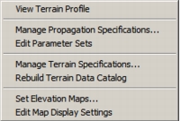
TMM adds several new operations to support these capabilities. These operations, accessed from the Topology > Terrain submenu (Figure 2), allow you to:
- view a terrain profile and signal attenuation along the path
- specify propagation models and environmental parameters
- specify terrain source files
- create elevation line maps from terrain source files, with varying degrees of detail
- display elevation lines with user-specified resolution and color
Figure 2: Terrain Submenu
In addition, the Terrain Modeling Module provides a variety of built-in functions you can include in your code to manipulate terrain data and use in custom Transceiver Pipeline stages.