Showing and Hiding Tactical Graphics
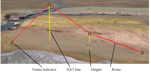
Tactical graphics are graphical objects that represent points, lines, and areal objects used for various purposes in simulations (Figure 85). They could represent routes that entities are following, a destination point, or a way to show some sort of relationship, such as height-above-terrain lines. You can configure the display of tactical graphics as follows:
- Enable and disable the display of tactical graphics
- Show or hide vertex indicators for point, linear, and areal objects
- Show or hide height-above-terrain lines
- Display height-above-terrain lines only for selected graphics
Figure 85: Tactical graphics height-above-terrain lines
Overlays
All tactical graphics are assigned to overlays. Overlays are conceptually similar to clear plastic sheets that you might layer over a map so that you easily add and remove supplementary information.
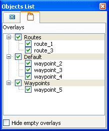
There is always at least one overlay – the Default overlay. However, VR-Forces users can create multiple overlays. When 3D Network Visualizer receives information about tactical graphics over the network, it lists the overlays and their respective graphics on the Overlays tab of the Objects List Panel (Figure 86).
Figure 86: Overlays tab
Showing and Hiding Tactical Graphics
You can control the display of tactical graphics from the Display Settings dialog box, Tactical Graphics Display settings page, from menu and toolbar options, and from the Objects List Panel Overlays tab.
Procedure 101: Showing or Hiding Tactical Graphics
-
Choose Settings > Display. The Display Settings dialog box opens.
-
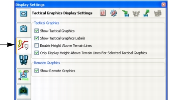
Select the Tactical Graphics Display Settings page (Figure 87).
Figure 87: Tactical Graphics Display Settings page
-
Select or clear the Show Tactical Graphics checkbox.
Note: You can also enable and disable tactical graphics by choosing Settings > Tactical Graphics Labels or clicking the Tactical Graphics icon (
 ) on the Display Settings Toolbar.
Showing and Hiding Tactical Graphics on the Overlays Tab
On the Overlays tab, you can show and hide tactical graphics individually and by overlay.
Procedure 102: Controlling the Display of Tactical Graphics from the Overlays Tab
- On the Objects List Panel, select the Overlays tab (Figure 86).
- To hide all graphics on a particular overlay, clear the checkbox for that overlay.
- To hide a specific tactical graphic, clear its checkbox.
- To redisplay a hidden tactical graphic or overlay, select its checkbox.
Showing and Hiding Vertex Labels
In addition to displaying models for tactical graphics themselves, you can display graphics (labels) for the vertices of these objects. Vertex labels are enabled in Figure 85.
Note: Displaying vertex labels can affect performance.
Procedure 103: Showing or Hiding Vertex Labels
-
Choose Settings > Display. The Display Settings dialog box opens.
-
Select the Tactical Graphics Display Settings page (Figure 87).
-
Select or clear the Show Tactical Graphics Labels checkbox.
Note: You can also enable and disable tactical graphics by choosing Settings > Tactical Graphics Labels or clicking the Tactical Graphics icon (
 ) on the Display Settings Toolbar.
Displaying HAT Lines for Vertices
You can display HAT lines for the vertices of tactical graphics. These vertical lines between an object’s vertices and the ground help you understand the relationship of the object to the terrain. The height for each vertex is displayed (using whatever units are configured on the Display Units Settings page) (Figure 85).
HAT lines are shown only for tactical graphics that could be above or below the ground, such as routes, and waypoints. You can show and hide these lines and you can specify that they be shown for all objects or only for the selected objects.
Note: Use of height above terrain lines can reduce the frame rate.
Procedure 104: Showing or Hiding Height-Above-Terrain Lines
- Choose Settings > Display. The Display Settings dialog box opens.
- Select the Tactical Graphics Display Settings page (Figure 87).
- To display HAT lines, select the Enable Height Above Terrain Lines checkbox.
- To only display lines for selected objects, select the Only Display Height Above Terrain Lines For Selected Tactical Graphics checkbox.