Specifying Display Units
You can specify the units used to display coordinate system, distance, altitude, and other measurements. Display units are configured by measurement type. This means that you can use different measurement units for different types of data. You can also specify the number of decimal places for measurement values. When you change a measurement display unit, the changes take effect immediately. They are saved and applied the next time you run 3D Network Visualizer.
Note: The following coordinate system and unit display information is independent of (and therefore not affected by) the settings described in this section:
- Coordinate system for cloud layers in the Add Cloud Layer dialog box.
- The coordinate system information for the observer location in the Observer Information Panel.
- Grid line coordinates, units, and precision.
The types of data and the display objects that they affect are as follows:
- Coordinate system
- Distance
- Altitude
- Velocity (speed)
- Acceleration
- Rotational velocity
- Orientation (heading)
Table 51 describes the coordinate systems that you can specify.
Table 51: Coordinate systems supported
| Coordinate system | Description |
|---|---|
| Latitude/Longitude (degrees:minutes:seconds) | Location is displayed as two position fields and one altitude field. Displays coordinates in the latitude and longitude using the Geodetic WGS84 coordinate system. Each angle will be displayed in Degrees:Minutes:Seconds with Seconds displaying base 10 fractional seconds. |
| Latitude/Longitude (decimal radians | Location is displayed as two position fields and one altitude field. Position coordinates in the latitude and longitude using the Geodetic WGS84 coordinate system. Each angle will be displayed in decimal radians. |
| Geocentric | Location is displayed as three position fields. Position coordinates are displayed in the geocentric coordinate system. The positions fields are always in meters. |
| UTM | Location is displayed as two position fields and one altitude field. Position coordinates are displayed in the Universal Transverse Mercator system. The first position field displays the Zone and the x location in meters. The second position field displays the y position in meters. |
| MGRS | Location is displayed as two position fields and one altitude field. Position coordinates are displayed in the Military Grid Reference System. The first position field displays the Zone. The second position field displays the grid location. The precision controls the number of digits used in the grid display. |
| Database | Location is displayed as three position fields. Location is displayed using 3D Network Visualizer's current internal cartesian Database system. The position fields will be displayed using the current Distance units. |
Procedure 226: Specifying measurement units
-
Choose Settings > Display. The Display Settings dialog box opens.
-
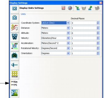
Select the Display Units Settings page (Figure 247).
Figure 247: Display Units Settings page
-
Select the measurement unit you want for each option from its drop-down list.
-
Type a precision for each measurement unit in the corresponding box in the Decimal Places column.